So much uncertainty with Beta with latest forecast
September 19, 2020
Beta still forecast to bring wind and rain to our area
September 19, 2020
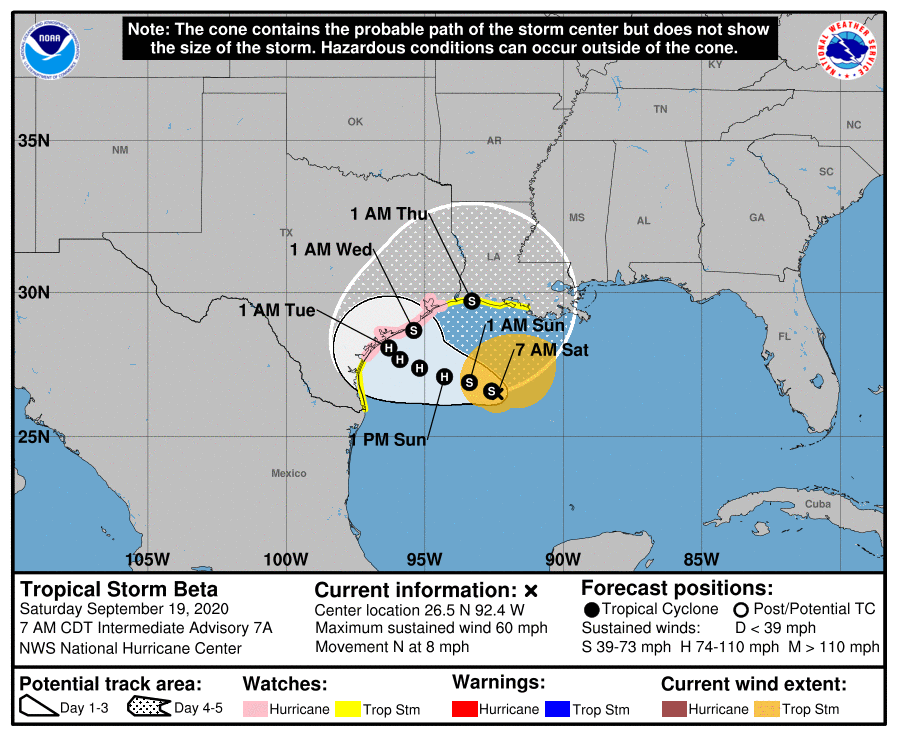
As Tropical Storm Beta starts its slow turn to the west, the coasts of Texas and Louisiana brace for prolonged periods of rainfall through the weekend and into next week.
At 10 a.m. CDT, the center of Tropical Storm Beta was located about 305 miles (495 km) east-southeast of Corpus Christi, Texas. Beta is moving toward the northwest near 3 mph (6 km/h). A slow westward motion is expected to begin later today, with a slow northwestward motion forecast to begin late Sunday or Sunday night and continue through late Monday. On the forecast track, the center of Beta will slowly approach the Texas coast into early next week.

Maximum sustained winds are near 60 mph (95 km/h) with higher gusts. Tropical-storm-force winds extend outward up to 175 miles (280 km) from the center. Little change in strength is expected today. After that, slow strengthening is forecast to occur, and Beta is expected to be at or near hurricane strength Sunday night or Monday.
Warnings have gone into effect:
A Storm Surge Watch is in effect for Port Mansfield, TX to Cameron, LA including Baffin Bay, Corpus Christi Bay, Copano Bay, Aransas Bay, San Antonio Bay, Matagorda Bay, Galveston Bay, Sabine Lake and Calcasieu Lake. A Hurricane Watch is in effect for Port Aransas Texas to High Island Texas. A Tropical Storm Warning is in effect for Port Aransas Texas to Intracoastal City Louisiana. A Tropical Storm Watch is in effect for South of Port Aransas Texas to the Mouth of the Rio Grande and East of Intracoastal City Louisiana to Morgan City Louisiana.

The combination of a dangerous storm surge and the tide will cause normally dry areas near the coast to be flooded by rising waters moving inland from the shoreline. The water could reach the following heights above ground somewhere in the indicated areas if the peak surge occurs at the time of high tide:
– Port Mansfield, TX to Cameron, LA including Baffin Bay, Corpus Christi Bay, Copano Bay, Aransas Bay, San Antonio Bay, Matagorda Bay, Galveston Bay, Sabine Lake, and Calcasieu Lake…2-4 ft
– Mouth of the Rio Grande, TX to Port Mansfield, TX…1-3 ft
– Cameron, LA to Morgan City, LA incl. Vermilion Bay…1-3 ft
Beta has the potential to produce a long-lived rainfall event along the western Gulf Coast. Today through Tuesday, Beta is expected to produce rainfall accumulations of 3 to 5 inches with isolated totals of 10 inches beginning Saturday across southern Louisiana and spreading into coastal Texas on Sunday. Flash and urban flooding is likely as well as minor river flooding. Additional heavy rainfall amounts across the western Gulf Coast are possible through late week as Beta is expected to move slowly near the Texas coast.

