
Gray woman arrested on felony drug charges
August 10, 2021
New LHSAA memo explains football games canceled for COVID-related reasons will result in forfeits
August 11, 2021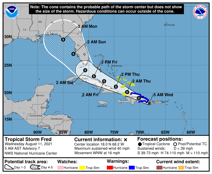
Tropical Storm Fred formed last night around 10pm. It will continue on a NW path with very little strengthening through the weekend. It still has a chance to get stronger if it stays over the warm waters of the Gulf for too long and a hurricane is certainly possible. Landfall is still forecast east of Louisiana in the Florida Panhandle area by early Monday
At 5 a.m. AST, the center of Tropical Storm Fred was located over the Caribbean Sea about 115 miles (190 km) east-southeast of Santo Domingo, Dominican Republic. It’s moving toward the west-northwest near 16 mph (26 km/h), and a general west-northwestward motion is expected to begin later today and continue for the next few days. On the forecast track, the center of Fred is expected to be near or over Hispaniola later today, move near the Turks and Caicos Islands and the southeastern Bahamas on Thursday, and move north of the northern coast of central Cuba on Friday.
Maximum sustained winds are near 40 mph (65 km/h) with higher gusts. Tropical-storm-force winds extend outward up to 45 miles (75 km) from the center. Some weakening is likely while the system interacts with Hispaniola later today.
A Tropical Storm Warning is in effect for the Dominican Republic on the south coast from Punta Palenque eastward and on the north coast from the Dominican Republic/Haiti border eastward.
A Tropical Storm Watch is in effect for Turks and Caicos Islands and the Southeast Bahamas.
Tropical storm conditions are expected in portions of the warning area in the Dominican Republic later this morning. Tropical storm conditions are possible along the northern coast of Haiti, the Turks and Caicos, and the southeastern Bahamas beginning late today.
Interests elsewhere in Haiti and the Bahamas, as well as in eastern and central Cuba, should monitor the progress of this system.. Interests in Florida should also monitor updates to the forecast as there is a risk of wind and rainfall impacts beginning Friday in the Keys and spreading northward through portions of the Peninsula and the Panhandle this weekend. However, it is too soon to determine the exact timing, location, and magnitude of any potential impacts.
For storm information specific to your area in the United States, including possible inland watches and warnings, please monitor products issued by your local National Weather Service forecast office. For storm information specific to your area outside of the United States, please monitor products issued by your national meteorological service.

