
Houma native rallies Natchitoches community to provide relief to her hometown following Ida
September 12, 2021
TPCG lists substations by street for customers
September 12, 2021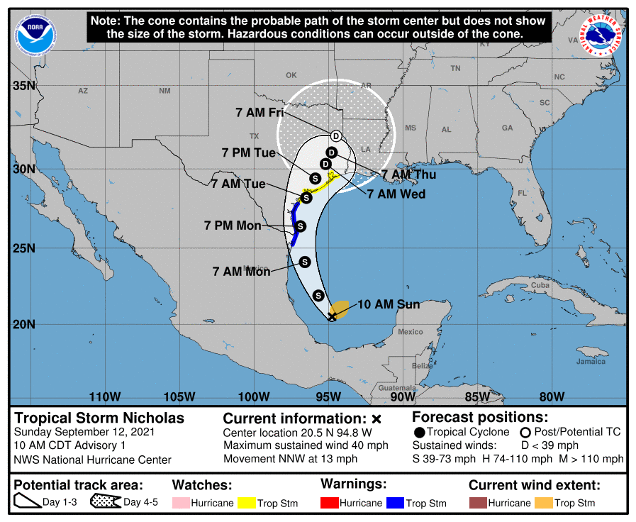
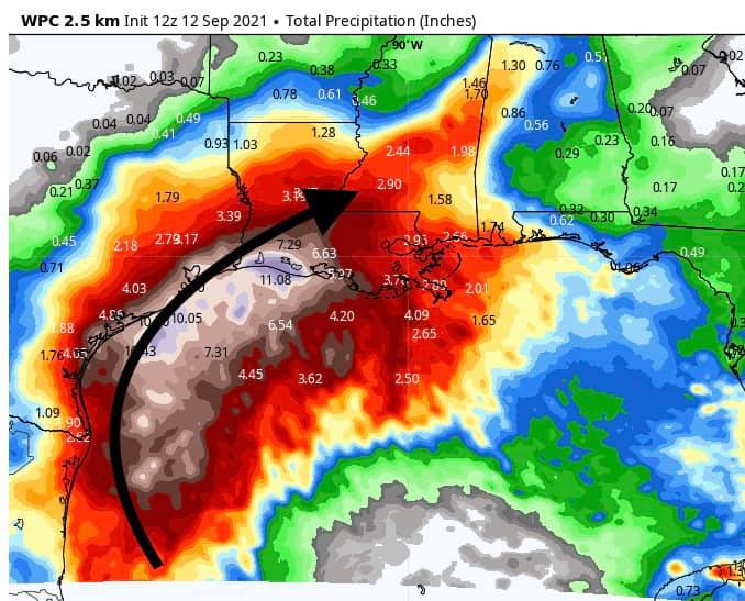
Tropical Storm Nicholas has formed in the Gulf. According to the forecast, Nicholas will move north slowly over the coming days and continue to strengthen. Rain is going to be our biggest problem with this system. Rain chances will increase today and throughout the week. NHC currently shows a 65mph tropical storm at landfall near Matagorda Bay, TX.
From NHC:
At 10 a.m. CDT, the center of Tropical Storm Nicholas was located over the southwest Gulf of Mexico about 130 miles (205 km) northeast of Veracruz, Mexico, and about 405 miles (650 km) south-southeast of the mouth of the Rio Grande River. Nicholas is moving toward the north-northwest near 13 mph (20 km/h), and this general motion is expected to continue through tonight. A slower northward or north-northeastward motion is forecast by late Monday or Monday night. On the forecast track, the center of Nicholas will pass near or just offshore the the coasts of northeastern Mexico and South Texas late Monday, and approach the south or central Texas coast Monday night or early Tuesday.
Data from an Air Force Reserve reconnaissance aircraft indicate that the maximum sustained winds are near 40 mph (65 km/h) with higher gusts. Tropical-storm-force winds extend outward up to 105 miles (165 km) from the center. The estimated minimum central pressure is 1008 mb (29.77 inches). Gradual strengthening is forecast to occur while Nicholas approaches the northwestern Gulf coast during the next day or so.
The combination of a dangerous storm surge and the tide will cause normally dry areas near the coast to be flooded by rising waters moving inland from the shoreline. The water could reach the following heights above ground somewhere in the indicated areas if the peak surge occurs at the time of high tide:
– Mouth of the Rio Grande to High Island, TX…2-4 ft
– Baffin Bay, Corpus Christi Bay, Aransas Bay, San Antonio Bay, Matagorda Bay, and Galveston Bay…2-4 ft.
Nicholas is expected to produce storm total rainfall of 5 to 10 inches, with isolated maximum amounts of 15 inches, across portions of coastal Texas into southwest Louisiana today through the middle of the week. This rainfall may produce areas of flash, urban, and isolated river flooding. Over the eastern portions of the Mexican state of Tamaulipas rainfall amounts of 2 to 5 inches can be expected today into Monday.
The next complete advisory will be issued by NHC at 4 p.m. CDT with an intermediate advisory at 1 p.m. CDT

