
Entergy update: Roads to be closed; Customer information centers opened
September 13, 2021
SLECA reports issues with Ashland, Matherne and Dulac substations
September 13, 2021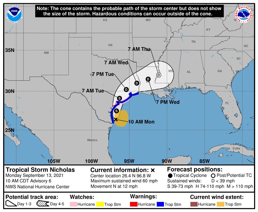
Rain, rain, rain…. Late Tuesday through Wednesday look like our highest chances for heavy rain associated with Tropical Storm Nicholas and possible flooding. The center of the storm has repositioned itself in the latest update, as the storm moves north into Texas. We will remain on the eastern side of the storm, most commonly known as the “dirty” or “wet” side of a tropical system. Please be sure your storm drains and ditches are clear of debris from Ida!!
At 10 a.m. CDT, the center of Tropical Storm Nicholas was located over the western Gulf of Mexico about 45 miles (70 km) northeast of the mouth of the Rio Grande River and about 140 miles (225 km) south of Port O’Connor, Texas. Nicholas is moving toward the north near 12 mph (19 km/h) and this general motion is expected to continue today, followed by a turn toward the north-northeast on Tuesday. On the forecast track, the center of Nicholas will pass near or just offshore of the coast of south Texas this morning and move onshore along the coast of south or central Texas late this afternoon or this evening.
Data from the reconnaissance aircraft indicate that maximum sustained winds remain near 60 mph (95 km/h) with higher gusts. Tropical-storm-force winds extend outward up to 115 miles (185 km) from the center. NOAA buoy 42020 located southeast of Corpus Christi, Texas, recently reported a sustained wind of 40 mph (65 km/h). The minimum central pressure recently measured by the aircraft is 1002 mb (29.59 inches). Strengthening is forecast to occur today, and Nicholas could reach the northwest Gulf coast as a hurricane. Weakening is anticipated on Tuesday and Wednesday while Nicholas moves over land.
The combination of a dangerous storm surge and the tide will cause normally dry areas near the coast to be flooded by rising waters moving inland from the shoreline. The water could reach the following heights above ground somewhere in the indicated areas if the peak surge occurs at the time of high tide:
– Port O’Connor to San Luis Pass TX including Matagorda Bay…3-5 ft
– San Luis Pass, TX to Rutherford Beach, LA including Galveston Bay…2-4 ft
– Baffin Bay to Port O’Connor, TX…2-4 ft
– Corpus Christi Bay, Aransas Bay and San Antonio Bay…2-4 ft
– Mouth of the Rio Grande to Baffin Bay…1-3 ft
– Rutherford Beach, LA to Intracoastal City, LA…1-3 ft
– Sabine Lake and Calcasieu Lake…1-3 ft
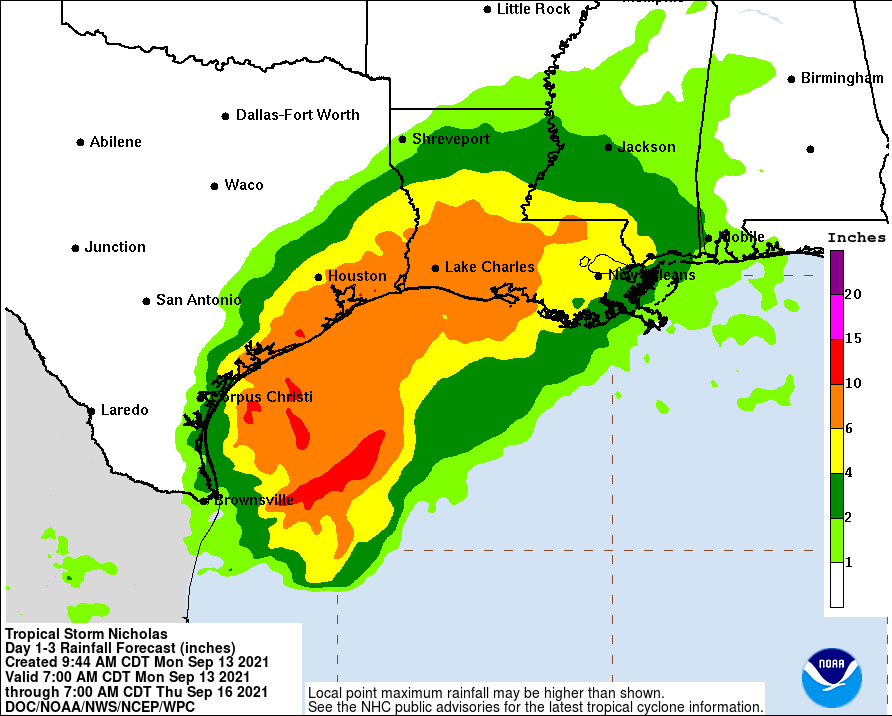
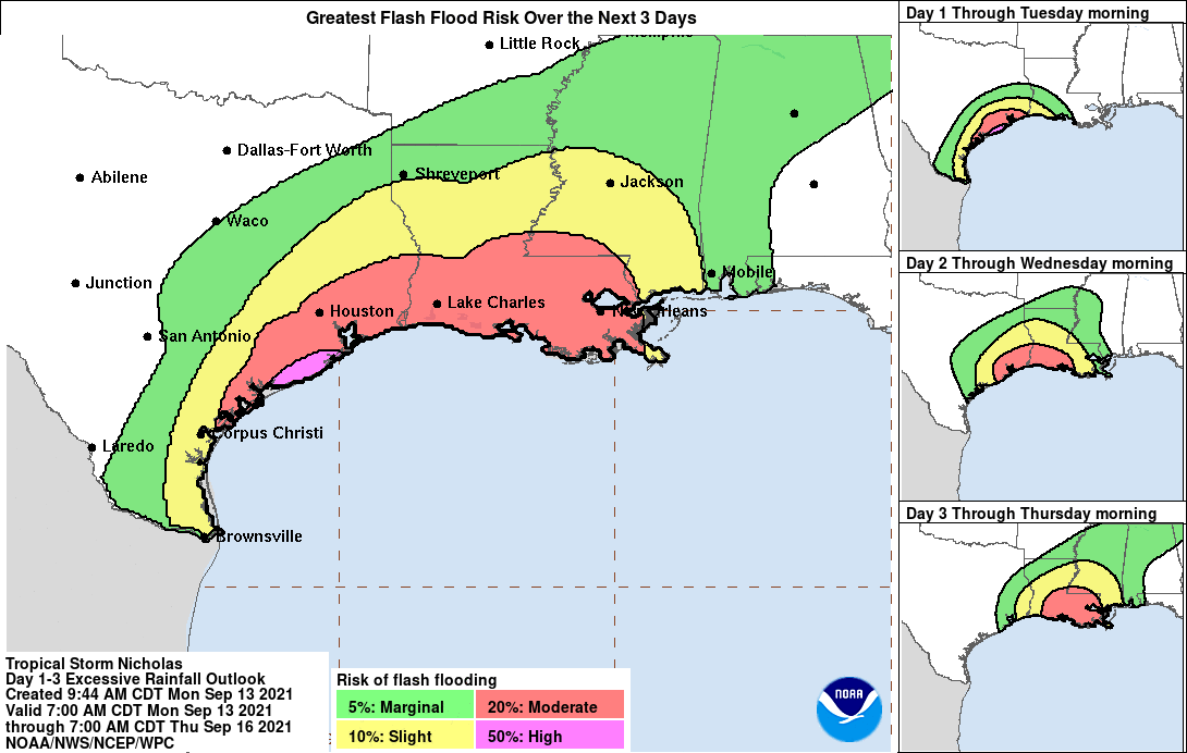
Nicholas is expected to produce storm total rainfall of 8 to 16 inches, with isolated maximum amounts of 20 inches, across portions of the middle and upper Texas coastal areas through the middle of the week. Life-threatening, flash and urban flooding impacts are possible, especially across portions of the upper Texas Gulf Coast near Lake Jackson and Freeport, TX. Across the rest of southeast Texas into southwest Louisiana rainfall of 5 to 10 inches is expected. This rainfall may produce areas of considerable flash and urban flooding, especially in highly urbanized metropolitan areas. Additionally, there is the potential for isolated minor to moderate river flooding..
Swells generated by Nicholas will continue affecting portions of the northwest Gulf coast through Tuesday. These swells are likely to cause life-threatening surf and rip current conditions.
A Storm Surge Warning is in effect for…
* Port Aransas Texas to Sabine Pass
* Galveston Bay, Aransas Bay, San Antonio Bay, and Matagorda Bay
A Hurricane Watch is in effect for…
* Port Aransas to San Luis Pass Texas
A Tropical Storm Warning is in effect for…
* Mouth of the Rio Grande to Sabine Pass
A Storm Surge Watch is in effect for…
* Baffin Bay to Port Aransas Texas
* Sabine Pass to Rutherford Beach Louisiana
* Corpus Christi Bay
Tropical storm conditions are expected within the warning area in southern Texas through the next few hours. These conditions will spread northward within the warning area through tonight, making outside preparations difficult or dangerous. Hurricane conditions are possible in the Hurricane Watch area as early as this afternoon or this evening.
A couple of tornadoes are possible this afternoon and tonight across the middle and upper Texas coast.
