
State Fire Marshal Offers Purchase, Use Tips As Fireworks Retail Sales for the Independence Day Holiday Begin
June 28, 2022
Bobbie Jean Hartzog Cheramie
June 28, 2022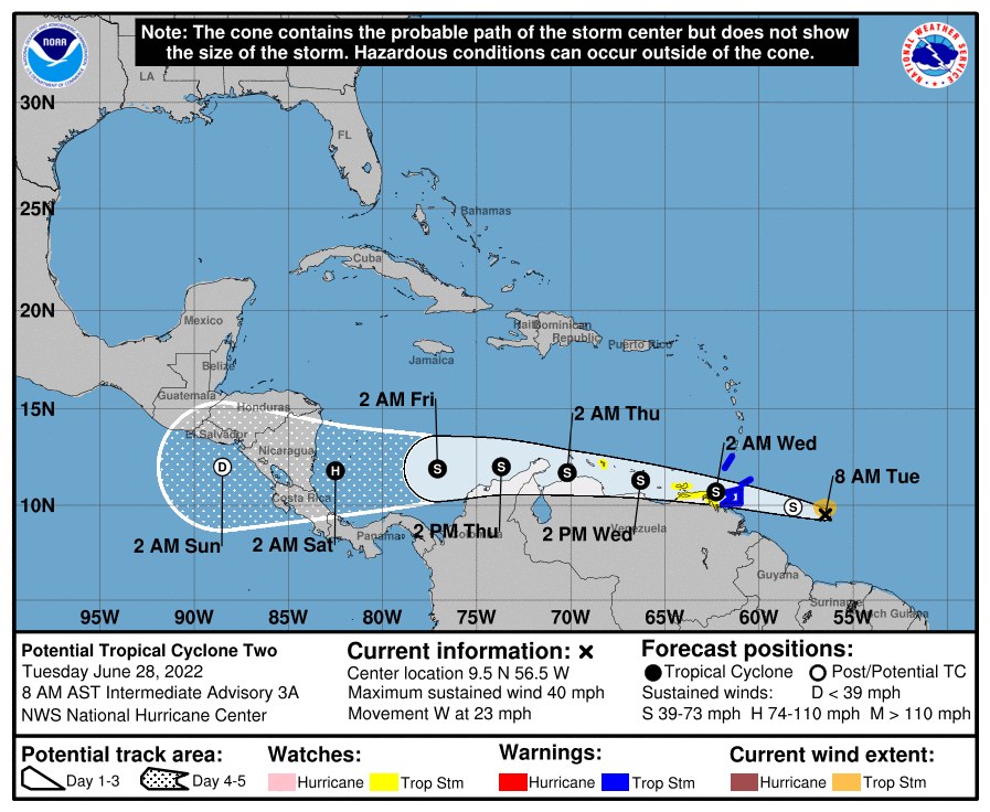
This morning’s update provides us a track for what looks to become Bonnie later today. We also continue to keep an eye on two other disturbances as they develop slowly.
East of the Windward Islands:
At 800 AM AST (1200 UTC), the poorly defined disturbance was about 330 miles (530 km) east of Trinidad. The system is moving toward the west near 23 mph (37 km/h). A westward or west-northwestward motion is expected through Thursday. On the forecast track, the system will pass near or over portions of the southern Windward Islands by tonight, and move over the southern Caribbean Sea or near the northern coast of Venezuela on Wednesday and Thursday. Maximum sustained winds remain near 40 mph (65 km/h) with higher gusts. Slight strengthening is forecast during the next few days if the disturbance remains over water. Conditions appear conducive for development if the disturbance remains over water, and it will likely become a tropical storm near the southern Windward Islands or while moving westward across the southern Caribbean Sea. It has a high (70 percent) chance of formation through 48 hours and a high (90 percent) chance in the next 5 days.

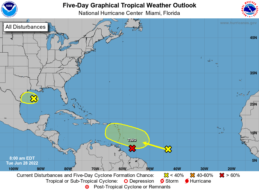
1. Northern Gulf of Mexico:
An area of low pressure is centered over the northwestern Gulf of Mexico. Shower and thunderstorm activity associated with the low has increased overnight but remains disorganized. Some additional development of this system is possible as it moves slowly westward or west-southwestward and approaches the coast of Texas during the next two days. Regardless of development, heavy rain will be possible along portions of the Texas coast later this week. For more information about the potential for heavy rain, please see products issued by your National Weather Service office.
* Formation chance through 48 hours…low…30 percent.
* Formation chance through 5 days…low…30 percent.
2. Central Tropical Atlantic:
A tropical wave located more than 1000 miles east of the Windward Islands continues to produce disorganized showers and thunderstorms. This system is forecast to interact with another tropical wave to its east over the next several days, and some gradual development is possible later this week while the overall system moves west-northwestward at around 15 mph across the central tropical Atlantic.
* Formation chance through 48 hours…low…near 0 percent.
* Formation chance through 5 days…low…20 percent.

