
Houma Fire Department, first responders to hold ceremony to “Never Forget”
September 10, 2020
What could Phase 3 look like?
September 11, 2020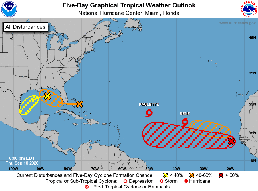
Every meteorologist on every news channel this evening has referred to this week as the heart of hurricane season. With four areas of interest and two named storms, the map concurs. This evening in Louisiana, all eyes are on the Gulf of Mexico, watching for potential development. At this time, forecasts call for tropical development early next week.
A large area of disorganized showers and thunderstorms extending from near the Central and Northwest Bahamas eastward over the western Atlantic for a few hundred miles, associated with a surface trough of low pressure. This system is forecast to move westward, crossing the Bahamas and Florida on Friday and moving into the eastern Gulf of Mexico over the weekend. Upper-level winds are expected to become conducive for development, and a tropical depression could form while this system moves slowly west-northwestward over the eastern Gulf of Mexico early next week. Regardless of development, this system is expected to produce locally heavy rainfall over portions of South Florida and the Keys during the next couple of days. It has a medium (50 percent) chance of formation during the next five days.
Another trough of low pressure is located over the north-central Gulf of Mexico. Although the associated shower and thunderstorm activity has diminished since earlier today, some slow development of this system is possible while it moves westward and then southwestward over the northern and western Gulf of Mexico through early next week. It has a low (20 percent) chance of formation during the next five days.
A tropical wave is located a few hundred miles southeast of the Cabo Verde Islands and is producing a large area of disorganized showers and thunderstorms. Gradual development of this system is forecast, and a tropical depression is expected to form within the next few days while the system moves generally westward across the eastern and central tropical Atlantic. It has a high (90 percent) chance of formation during the next five days.
Another tropical wave is forecast to emerge off the west coast of Africa this weekend. Environmental conditions are expected to be conducive for development, and a tropical depression could form over the far eastern tropical Atlantic early next week while the system moves slowly westward. It has a medium (40 percent) chance of formation during the next five days.

