
Lafourche Water District issues Water Conservation Notice
December 20, 2022
Start Corporation announce Veteran’s Crisis Prevention and Behavioral Health Crisis Walk-In Center in Houma
December 20, 2022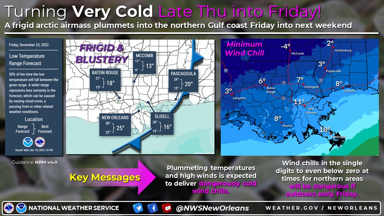
We are still anticipating an extremely cold airmass to surge towards the Gulf coast Thursday and Thursday Night.
This airmass will lead to a multitude of hazardous conditions across the area. Hard Freeze, duration of freezing temps, very strong winds, and dangerous Wind Chill conditions would begin as early as Thursday night and will continue to impact the region even after Christmas.
Now is the time to start taking measures to protect your family, pets, friends, property, and yourself from the likelihood of extreme and prolonged freezing conditions for southern Mississippi and southeast Louisiana. The Arctic airmass will start to surge south out of Canada and across the central United States Wednesday and Wednesday night and approach the Lower Mississippi Valley Thursday. The cold front is expected to move at a rapid clip likely entering southwest Ms around or shortly after sunset. The cold front will not slow down and should be well into the Gulf before sunrise.

Once the front moves through temperatures will rapidly drop and could fall by some 20 to 30 degrees or more in only a few hours. Temperatures will continue to plummet through the early morning hours with almost the entire area below freezing around sunrise.
The rapid temperature drop will be accompanied by very strong and possibly damaging winds which will also produce dangerous and possibly life threatening wind chill readings. The wind chill is now expected to fall into the single digits and lower teens over a large portion of the area Friday morning; there is even a small chance of a few locations registering a wind chill of below zero.
Impacts:

First, the extremely cold temperatures that are being forecast. As we mentioned there is a lot out there that says it is possible to see morning lows in the single digits and that would be a first for almost every location in the area since 1996. Lows this cold will absolutely wreak havoc on exposed pipes, sensitive vegetation, and possibly fatal to many animals and people if they are unable to find cover and warm up.
Second, the duration. There is a good chance that many locations drop below freezing early Friday and won’t see 33 degrees or warmer till Saturday afternoon. And even if they did it would be such a short duration above freezing that it would be almost negligible. This would lead to a number of locations experiencing as much as 30 to 36 hours of below freezing temps. Locations that stay below freezing all day Friday would be expected to climb above freezing Saturday afternoon but that may only be for 2 to 4 hours leading to some locations possibly being at or below 32 degrees for approximately 55 out of 60 hours.
Third, the wind. The wind will be absolutely brutal for multiple reasons. One, it could be damaging leading to loss of power along with hazardous driving conditions. Two, it will make the wind chill quite dangerous. The winds will be out of the north and north-northwest which is perpendicular to interstates 10 and 12 along with major US hwy 190. Wind gusts of 35 to 45 mph maybe topping out around 50 mph will be quite hazardous along the elevated highways and to high profile vehicles. Also wind gusts of this magnitude can bring down weak or dead trees and/or previously damaged tree limbs onto powerlines, vehicles, and even you if you are outside. Christmas decorations should be secured otherwise your neighbor some 2 to 3 blocks away could be the new owner.

Wind Chill. So with the combination of very cold temperatures and very strong winds, we are expecting to deal with dangerous if not life threatening wind chill values for the Gulf coast. These values aren’t crazy overall but for south MS and south LA we are just not used to this. Many will not have the proper clothing to protect against this. If you must be outside make sure to dress in layers. Try to find as many breaks as possible to take cover to warm up. Exposed skin is the most crucial part and your body heat will quickly be pulled away with these winds which could lead to Hypothermia and that can set in very quickly.
Travel. This is the Christmas Holiday weekend and with Christmas on a Sunday there is a very good chance that a large majority of people will begin their travel to their destination on Friday. With road congestion expected to be much greater than normal the winds will complicate things making travel somewhat hazardous. The other concern is given the amount of people expected on the road, any accident could lead to far greater and longer backups. If you get caught in a traffic jam or your vehicle breaks down on Friday, this could quickly turn into a more dire situation. If you are unable to get off the road and warm up you will have the potential of becoming a victim of the cold. Plan ahead to bring extra gear such as additional clothes which includes socks, undergarments, and a hat. Never underestimate the benefit of a pair of DRY SOCKS and a HAT. Also bring multiple blankets. Just a few easy things to remember that we normally don’t have to concern ourselves with.
