
Lois S. Boudreaux
June 10, 2011
Construction on Bayou-themed kids’ museum to begin soon
June 14, 2011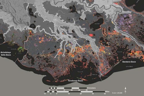
Coastal Louisiana supports the largest commercial fishing industry in the continental United States and is among the most active in terms of offshore oil exploration and commercial shipping.

Louisiana has the seventh largest delta area on earth with half of the state’s 4.5 million residents living in coastal parishes.

It is also a coastline that residents and environmentalists have warned for decades is sinking into non-existence.
A new map produced by the U.S. Geological Survey National Wetlands Research Center has confirmed that during a 78-year period between 1932 and 2010, roughly 1,883 square miles, or 25 percent of Louisiana’s wetlands have been lost to combined elements of erosion due to tropical storms and hurricanes as well as coastal cutting by industry, the construction of certain dams and levees and most significantly the rerouting of major waterways including the Mississippi River following the great flood of 1927 that robbed the region of needed sediment for prolonged survival.

The map was released last week during a joint Natural Resources committee meeting with the Louisiana House of Representatives and Senate.
“This issue is vital to the citizens of southern Louisiana and Terrebonne Parish in particular,” state Rep. Gordon Dove (R-Houma) said. Dove chairs the House Natural Resources and Environment committee and specifically noted that his home parish is among the areas posting the greatest wetland loss according to a USGSNWRC study, upon which the map was constructed.
Researchers specifically noted the Terrebonne Basin, Breton Sound, Barataria, and communities including Golden Meadow, Grand Isle, Houma, Thibodaux and New Orleans as populated areas of greatest concern.
“By understanding land change on the Louisiana coast, decisions makers can make informed choices about how to actively manage the land to help reduce future loss,” USGAWRC Director Phil Turnipseed said. “We can’t manage what we don’t measure.”
The concentrated study revealed that there was rapid loss with the pace of disappearing wetlands between 1956 and 1978 being an estimated average of 30 square miles per year. That rate slowed to almost 12 square miles per year between 1985 and 2004.
With a series of major hurricanes making landfall on Louisiana between 2005 and 2008 being added as a factor, land loss increased to more than 16 square miles per year between 1985 and 2010.
Dove has gone on record, previous to the release of this map and study, as an advocate for sediment relocation. Following Thursday’s hearing, he said that this report offered justification to divert water from the Atchafalaya River into southern Terrebonne Parish for the purpose of coastal restoration, and could lead to federal assistance in funding such a project. “The federal government believes in federal government reports. The USGS has really done a good job and this report will help.”
A new map produced by the U.S. Geological Survey National Wetlands Research Center confirms what local residents have known for decades that between 1932 and 2010 coastal Louisiana has been sinking. Map by USGSNWRC
