
Laura’s high winds continue to increase; 115 mph winds are forecasted with gusts up to 140 mph
August 25, 2020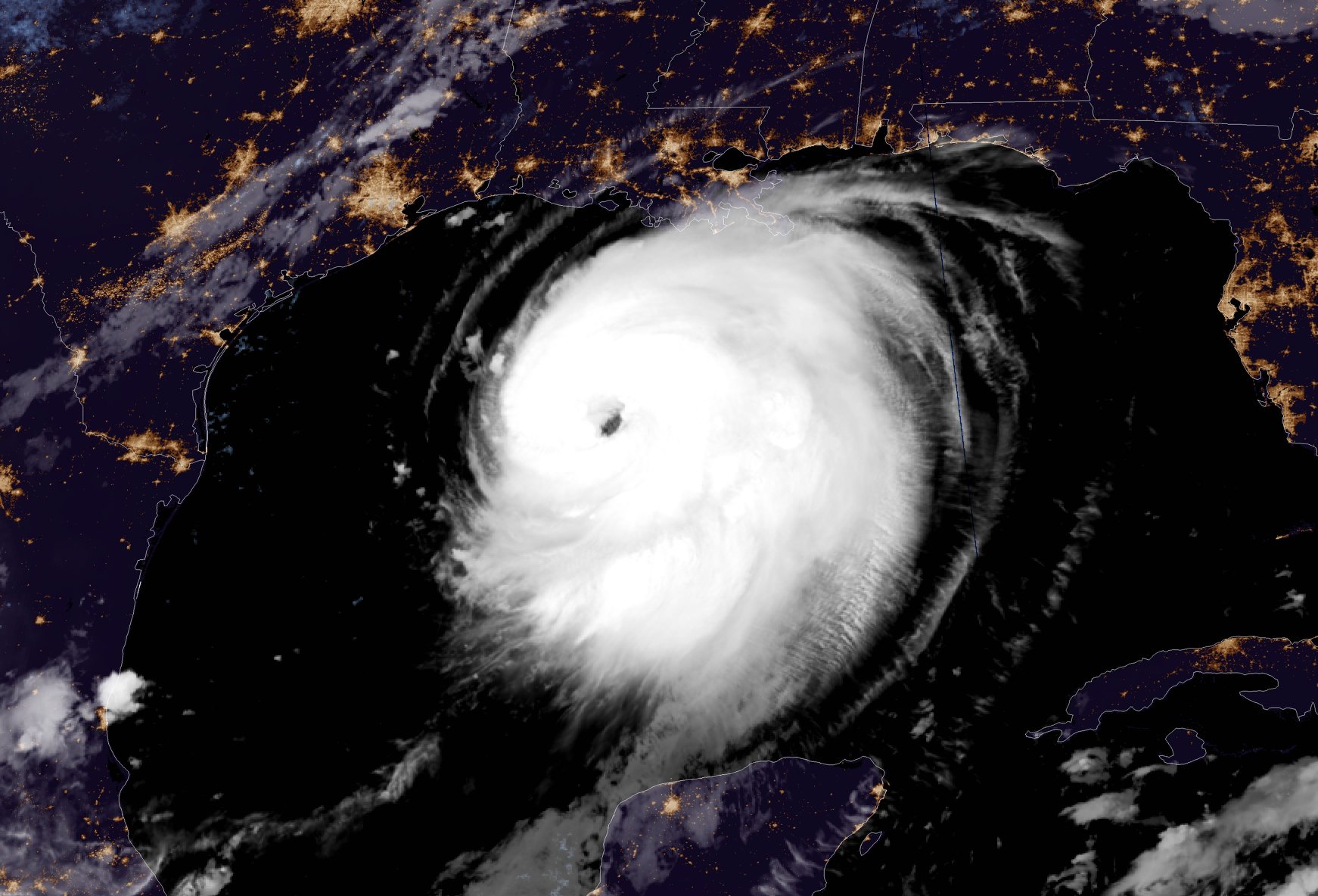
Laura becomes category 3 storm; further strengthening expected
August 26, 2020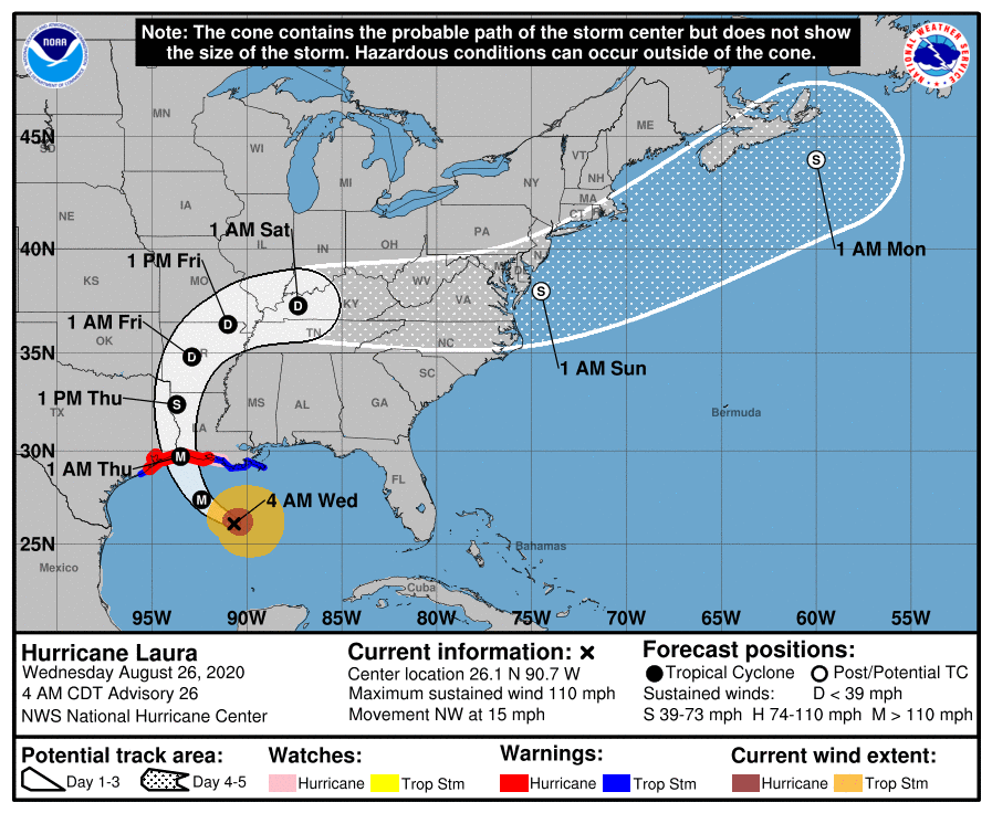
Overnight, Laura has continued to intensify into a category 2 storm and is now expected to strengthen into a category 4 storm today. Laura is expected to make landfall as a category 3 storm. A clear eye wall has started to develop. We are still under a tropical storm warning, and a storm surge warning from 4-7 feet. We will start to feel the winds pick up this afternoon into tropical storm force winds and may have a stray shower or two. Thursday will be when our area will start to get the bands off of Laura, bringing heavier rain and. a chance of tornadoes.
![]()
Hurricane conditions are expected in the hurricane warning area tonight and Thursday. Tropical storm conditions are expected to reach the coast in the hurricane warning area late today or tonight, and are expected in the tropical storm warning area tonight and Thursday. Hurricane-force winds and damaging wind gusts are also expected to spread well inland into portions of eastern Texas and western Louisiana early Thursday.
A few tornadoes are expected this evening through tonight over Louisiana, far southeast Texas, and southwestern Mississippi. The risk for a few tornadoes should continue into Thursday across Louisiana, Arkansas, and western Mississippi.

At 4 a.m. CDT, the center of Hurricane Laura was located about 315 miles (510 km) south-southeast of Lake Charles, La. It’s moving toward the northwest near 15 mph (24 km/h) and this general motion should continue today, and a north-northwestward motion is forecast tonight. On the forecast track, Laura should approach the Upper Texas and southwest Louisiana coasts on this evening and move inland near those areas tonight or Thursday morning.
Satellite data indicate that maximum sustained winds have increased to near 110 mph (175 km/h) with higher gusts – a category 2 hurricane on the Saffir-Simpson Hurricane Wind Scale. Laura is becoming a large hurricane. Hurricane-force winds extend outward up to 70 miles (110 km) from the center and tropical-storm- force winds extend outward up to 175 miles (280 km). Laura is forecast to become a category 4 hurricane today, and is expected to be a major hurricane at landfall. Rapid weakening is expected after Laura makes landfall.
The combination of a dangerous storm surge and the tide will cause normally dry areas near the coast to be flooded by rising waters moving inland from the shoreline. The water could reach the following heights above ground somewhere in the indicated areas if the peak surge occurs at the time of high tide…
– Sea Rim State Park to Intracoastal City incl. Sabine Lake & Calcasieu Lake…10-15 ft
– Intracoastal City to Morgan City including Vermilion Bay…8-12 ft
– Port Bolivar to Sea Rim State Park…6-9 ft
– Morgan City to Mouth of the Mississippi River…4-7 ft
– San Luis Pass to Port Bolivar…3-5 ft
– Galveston Bay…3-5 ft
– Mouth of the Mississippi River to Ocean Springs including Lake Borgne…2-4 ft
– Lake Pontchartrain and Lake Maurepas…2-4 ft
– Freeport to San Luis Pass…2-4 ft

From this afternoon through Friday, Laura is expected to produce rainfall totals of 5 to 10 inches, with isolated maximum amounts of 15 inches across portions of the northwestern Gulf Coast from western Louisiana to far eastern Texas, and northward into much of Arkansas. Over the lower to middle Mississippi Valley from central Louisiana into western Tennessee and Kentucky, and southeastern Missouri, 2 to 4 inches of rainfall with isolated totals of 6 inches are expected. This rainfall will cause widespread flash and urban flooding, small streams to overflow their banks, and minor to isolated moderate river flooding.
The next complete advisory will be issued by NHC at 10 a.m. CDT with an intermediate advisory at 7 a.m. CDT

