
Evacuations begin on Grand Isle ahead of Cristobal
June 5, 2020
Bayouside with Benny Cenac: Boudin
June 5, 2020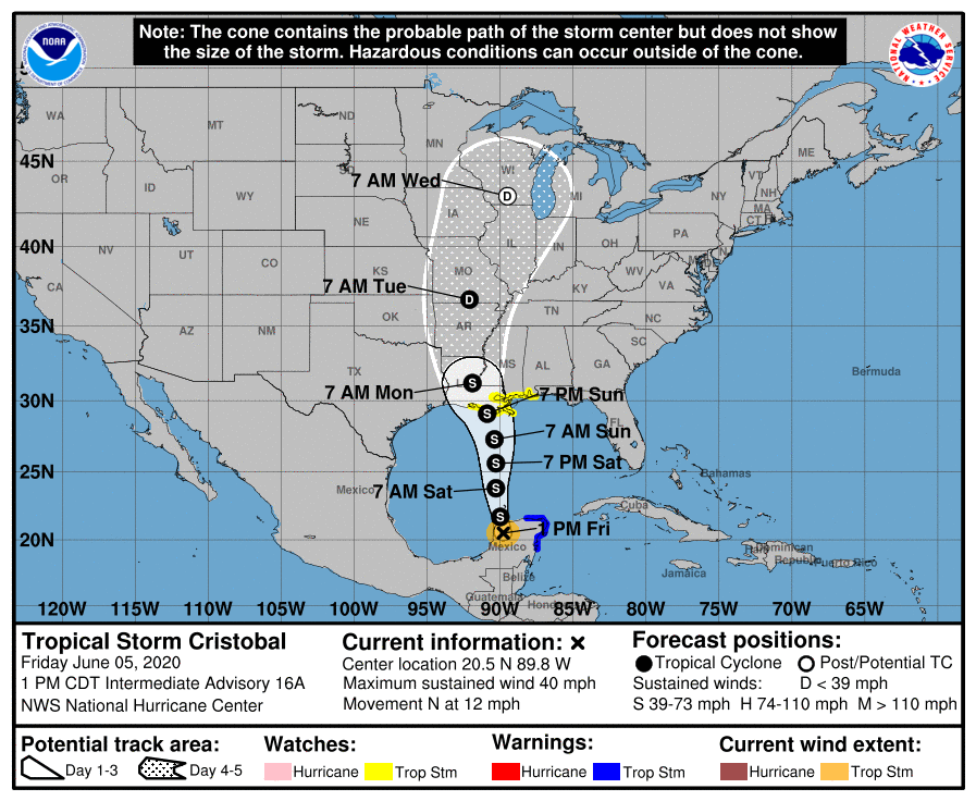
Cristobal is a tropical storm again, still moving over eastern Mexico.
From the NWS, a summary of watches and warnings that are currently in effect:

A Storm Surge Watch is in effect for…
* Indian Pass to Arepika, Florida
* Grand Isle, Louisiana to Ocean Springs, Mississippi
* Lake Borgne
A Storm Surge Watch means there is a possibility of life-threatening inundation, from rising water moving inland from the coastline, in the indicated locations during the next 48 hours. The water could
reach the following heights above ground somewhere in the indicated areas if the peak surge occurs at the time of high tide:
• Aripeka to Marco Island including Tampa Bay…1-3 ft
• Grand Isle to Ocean Springs including Lake Borgne…2-4 ft
• Indian Pass to Aripeka…2-4 ft
• Ocean Springs to Indian Pass including Mobile Bay and Pensacola Bay…1-3 ft

The deepest water will occur along the immediate coast in areas of onshore winds and will likely extend along the coast well to the east of the center.
A Tropical Storm Watch is in effect for:
* Intracoastal City, Louisiana to the Alabama/Florida border
* Lake Pontchartrain and Lake Maurepas
A Tropical Storm Watch means that tropical storm conditions are possible within the watch area, generally within 48 hours.

———————-
At 100 PM CDT (1800 UTC), the center of Tropical Storm Cristobal was located near latitude 20.5 North, longitude 89.8 West. The storm is moving toward the north near 12 mph (19 km/h), and this general motion is expected to continue for the next couple of days. On the forecast track, the center will move back over the southern Gulf of Mexico this evening, over the central Gulf of Mexico on Saturday,
and be near the northern Gulf of Mexico coast Sunday evening.
Satellite-derived wind data and surface observations indicate that Cristobal’s maximum sustained winds have increased to near 40 mph (65 km/h) with higher gusts. Some additional strengthening is
forecast during the next 48 hours.
Tropical-storm-force winds extend outward up to 240 miles (390 km) from the center. The estimated minimum central pressure is 1000 mb (29.53 inches).

RAINFALL: Cristobal is expected to produce the following rain accumulations:
Through Wednesday morning, for portions of the eastern and central Gulf Coast and the lower Mississippi Valley, rainfall accumulations of 4 to 8 inches, with local amounts to 12 inches, are forecast.
Isolated significant river flooding is possible along the central Gulf Coast. Farther north across the Mid-Mississippi Valley, rainfall totals of 2 to 4 inches, with local amounts to 6 inches, are expected. Rises along smaller-order streams are possible across the Mid-Mississippi Valley. This degree of rainfall is
expected to lead to flash flooding.

