
Leo Cavell
May 24, 2011
James Walker
May 26, 2011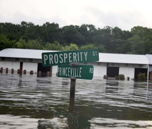
The U.S. Army Corps of Engineers partially opened one gate at the Morganza Spillway May 14 and created a flow of water at 10,000 cubic feet per second to be transferred from the Mississippi River into the Atchafalaya River Basin.

By Sunday, 17 gates were opened to a flow rate of 114,000 cubic feet per second and residents’ communities like Krotz Springs and Butte Larose were told they should evacuate before a stream some 20 miles wide and potentially 30 feet deep reached their areas.
Approximately 150 miles downstream of the spillway, Morgan City was expected to see a river crest on May 23, then it was May 25, and now it is May 29. Locals joined work efforts with the National Guard and parish workers as sandbags, Hesco baskets, pumps and other flood-deterrent equipment was put in place and levees were fortified.

The warnings were to expect record flooding as previously seen in 1973 and 1927. Eleven days later, residents in lower Assumption, St. Mary and western Terrebonne parishes, which were predicted to see a month’s worth of standing water take over were still waiting to see what they had been warned about.

“The models play into it and historical information plays into it,” said National Weather Service hydrologist Jeff Graschel regarding the pushing back of projected flooding and river crest dates. “Those as the two key things that we look at. As we go in time, seeing how this floodway is moving through plays into looking at real time sense as well.”
Graschel echoed what government officials and long-time residents have suggested, that the building of flood protection levee systems that were not in place during either of the previous historic backwater floods are making a difference. Those measures need to also be held in balance with the fact that long stretches without rain has caused the ground to absorb more moisture than was the case during previous water events.

“The slowness of the water from the Morganza to make its way down the Atchafalaya is really the key as to why the [crest] dates have been pushed back a little bit,” Graschel said.

This hydrologist said preliminary assumptions were made based on what flooding was being seen upstream on the Mississippi River in combination with the patterns of past occurrences.
“[The cause of the slower than expected water flow] will have to be evaluated over time after the event is over,” Graschel said. “Trees, shrubs and frictional effects play a role. There is probably not any one thing that we will be able to put our thumb on and make a decision as to about why.”

Graschel admitted that he was not sure if pushing back the expected crest dates is a good or a bad sign. “It is a good thing in that it allows for more preparation,” he said. “If we do get to the levels we are forecasting for it does allow people to be able to make preparations over a long period of time.”
According to Graschel, there is the potential that a wave continuation could get absorbed in channels and reduce water peaks.
Based on what the NWS had seen to this point, Graschel said the forecast for Bayou Sorrel lock Amelia Point and Morgan City seem to be tracking to an 18-foot flood level in Bayou Sorrel and 11-foot level in Morgan City on May 29.
Graschel said some areas on the backside of the levee systems are concerned about backwater flood. No big difference is expected from locations downstream of Bayou Sorrel and southward.
U.S. Army Corps of Engineers spokesman Ricky Boiett confirmed the elements mentioned by Graschel. “The system is still under pressure, but is working as it is designed to do,” Boiett added as a factor that might have played into the slower than expected flood flow.
As of Monday, Graschel said the forecast was a continued expectation of 18-feet and 11-feet flooding on the front sides of Bayou Sorrel and Morgan City. He said that while they are watching rains in northern Louisiana and stretching into Missouri, those storms are not expected to influence flooding in the state’s coastal parishes.
“We would have to get heavier rainfall in the Alexandria area southward to really cause areas on the Atchafalaya River to potentially go up,” Graschel said. “Right now, none of the models are indicating that. If the model projections are right, what we are anticipating is a slowdown of the [water] recessions as we get into the mid-part of June.”
Many government and levee officials have predicted that once serious floodwaters hit St. Mary and Terrebonne parishes, it could take as much as a month for the waters to begin to recede.
A street sign is seen in floodwaters from the rising Mississippi River in St. Francisville, La., where a dozen homes and businesses, and several camps, were flooded Friday. AP PHOTO

