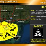
Critical Fire Weather Conditions Update for Monday
August 21, 2023
Synergy Bancshares, Inc. completes acquisition of Peoples Bancshares of Pointe Coupee Parish, Inc.
August 21, 2023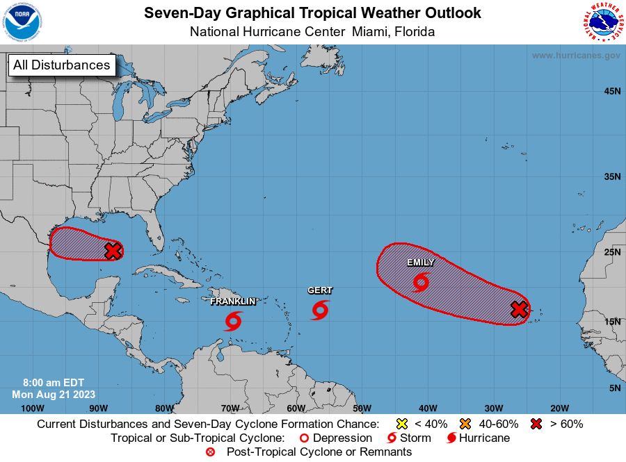
Three named storms formed over the weekend. We will provide the updates on the storms here, along with the forecast for the other areas of interest:

1. Western Gulf of Mexico (AL91):
Showers and thunderstorms are showing signs of organization in association with a broad area of low pressure located over the central Gulf of Mexico. Environmental conditions appear conducive for development of this system, and a tropical depression or tropical storm is likely to form before it reaches the western Gulf of Mexico coastline on Tuesday. Interests in southern Texas and northern Mexico should monitor the progress of this system as tropical storm watches or warnings are likely to be issued later today.
* Formation chance through 48 hours…high…80 percent.
* Formation chance through 7 days…high…80 percent.
2. Eastern Tropical Atlantic (AL92):
Showers and thunderstorms over the Cabo Verde Islands and portions of the tropical eastern Atlantic are associated with a tropical wave. Environmental conditions appear generally conducive for gradual development of this system, and a tropical depression is likely to form later this week while it moves west-northwestward across the eastern tropical Atlantic.
* Formation chance through 48 hours…medium…40 percent.
* Formation chance through 7 days…high…70 percent.
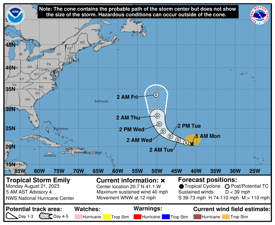
TROPICAL STORM EMILY

At 500 AM AST (0900 UTC), the center of Tropical Storm Emily was located near latitude 20.7 North, longitude 41.1 West. Emily is moving toward the west-northwest near 12 mph (19 km/h), and a west-northwest to northwest motion is expected during the next couple of days. A turn to the north is forecast by the middle part of the week.
Maximum sustained winds have decreased to near 40 mph (65 km/h) with higher gusts. Further weakening is forecast, and Emily could become a post-tropical cyclone by this evening.
Tropical-storm-force winds extend outward up to 205 miles (335 km) from the center. The estimated minimum central pressure is 1004 mb (29.65 inches).

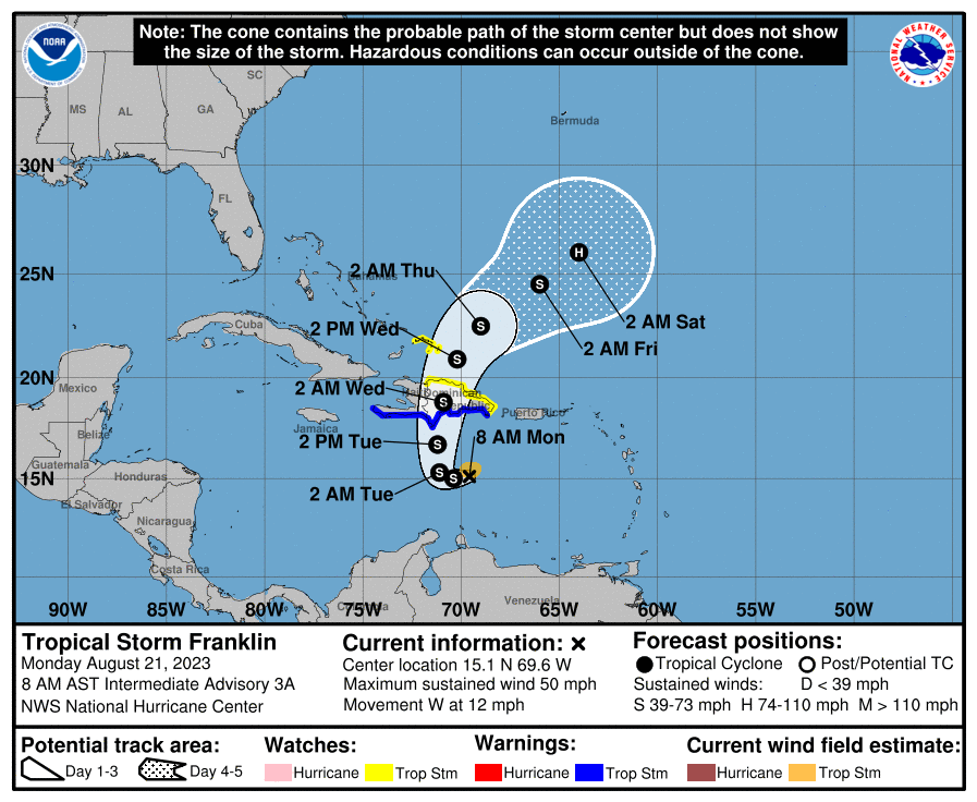
TROPICAL STORM FRANKLIN
At 800 AM AST (1200 UTC), the center of Tropical Storm Franklin was located near latitude 15.1 North, longitude 69.6 West. Franklin is moving toward the west near 12 mph (19 km/h). A westward to west-northwestward track is expected to continue today. A sharp turn to the north is expected tonight or early Tuesday, and a generally northward motion is expected on Tuesday. On the forecast track, the center of Franklin is forecast to reach the southern coast of Hispaniola late Tuesday or Tuesday night.
Maximum sustained winds are near 50 mph (85 km/h) with higher gusts. Some strengthening is forecast before Franklin reaches Hispaniola.

Tropical-storm-force winds extend outward up to 60 miles (95 km) from the center. The estimated minimum central pressure is 999 mb (29.50 inches).
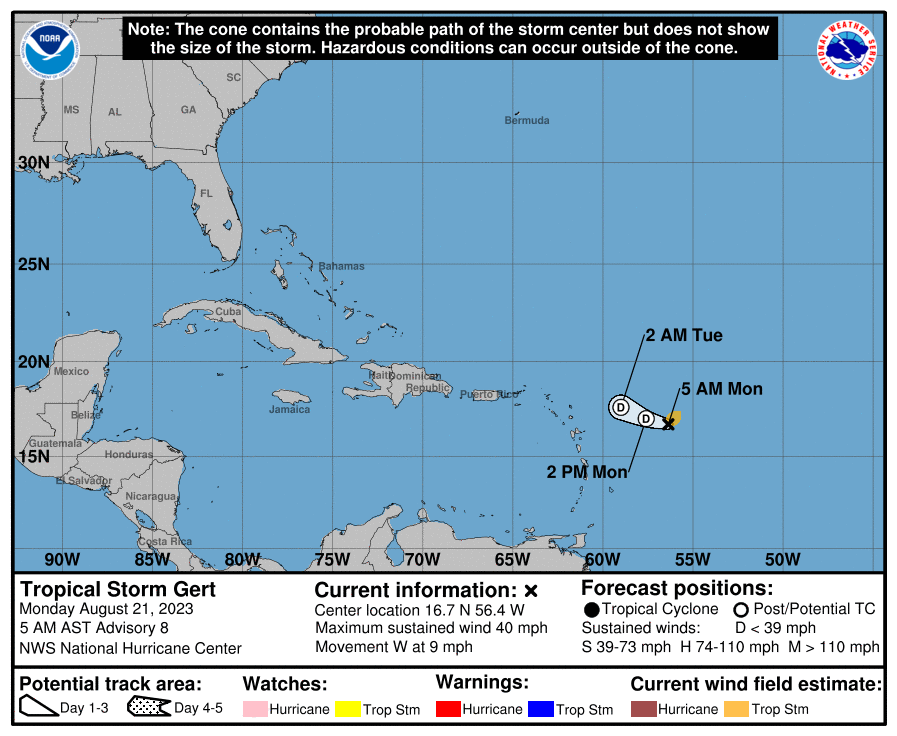
TROPICAL STORM GERT
At 500 AM AST (0900 UTC), the center of Tropical Storm Gert was located near latitude 16.7 North, longitude 56.4 West. Gert is moving toward the west near 9 mph (15 km/h), and a gradual turn toward the west-northwest is forecast by tonight.

Maximum sustained winds are near 40 mph (65 km/h) with higher gusts. Gert is expected to become a remnant low later today and dissipate on Tuesday.
Tropical-storm-force winds extend outward up to 70 miles (110 km) from the center. The estimated minimum central pressure is 1006 mb (29.71 inches).

