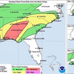
Disturbance yet to develop into tropical cyclone, but still has a ‘high chance’ to
June 18, 2021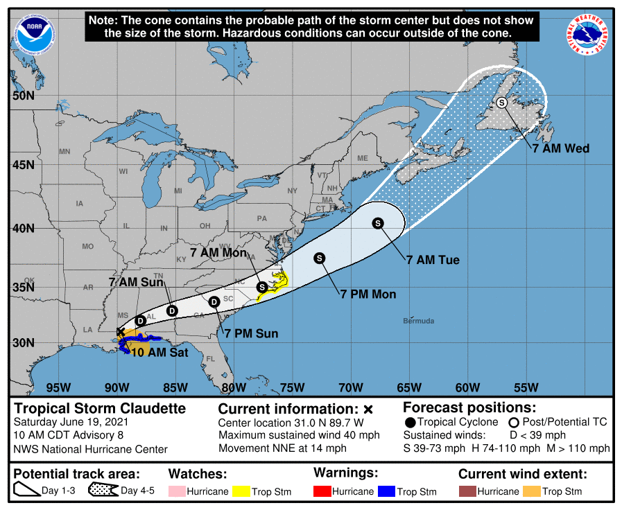
Tropical Storm Warning lifted in the region as Claudette moves out of Louisiana
June 19, 2021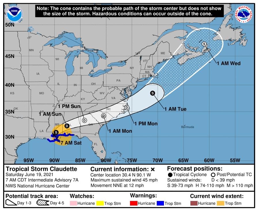
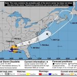
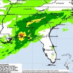
Tropical Storm Claudette has formed and is inland over Southeast Louisiana.
From the National Hurricane Center:
…CLAUDETTE INLAND OVER SOUTHEASTERN LOUISIANA…
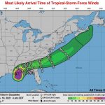
…HEAVY RAINS AND TROPICAL-STORM-FORCE WINDS CONTINUE ALONG PORTIONS OF THE NORTHERN GULF COAST…
A Tropical Storm Warning continues from east of Morgan City, Louisiana, to the Okaloosa/Walton County line Florida, including Lake Pontchartrain, Lake Maurepas, and Metropolitan New Orleans. Tropical storm conditions should continue along the coast in the warning area today.

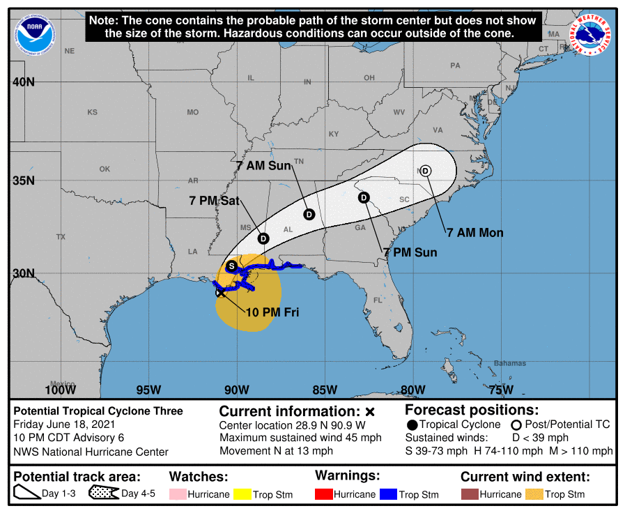
At 7 a.m. CDT, the center of Tropical Storm Claudette was located inland over southeast Louisiana about 30 miles (45 km) north of New Orleans. It’s moving toward the north-northeast near 12 mph (19 km/h). A turn toward the northeast is expected later today, followed by a motion toward the east-northeast tonight or Sunday. On the forecast track, the system should move farther inland over Louisiana during the next few hours, move across portions of the southeastern states later today and on Sunday, and then over the western Atlantic Ocean on Monday.
Maximum sustained winds remain near 45 mph (75 km/h) with higher gusts. Tropical-storm-force winds extend outward up to 205 miles (335 km) east of the center. A National Ocean Service station on Petit Bois Island, Mississippi, recently reported maximum winds of 39 mph (63 km/h) with a gust to 46 mph (74 km/h). Claudette is expected to weaken to a tropical depression by tonight and become a post-tropical cyclone on Sunday. The system is forecast to become a tropical storm again over the western Atlantic Ocean on Monday.
Claudette is expected to produce rainfall totals of 5 to 10 inches with isolated maximum amounts of 15 inches across portions of the central Gulf Coast. Life-threatening flash flooding impacts are possible across coastal Mississippi and Alabama, and the far western Florida Panhandle through the afternoon. Considerable flash, urban and small stream flooding impacts as well as new and renewed minor to isolated moderate river flooding are likely across the remainder of the Central Gulf Coast.

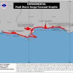
The combination of storm surge and the tide will cause normally dry areas near the coast to be flooded by rising waters moving inland from the shoreline. The water could reach the following heights above ground somewhere in the indicated areas if the peak surge occurs at the time of high tide…
– Morgan City, LA to Okaloosa/Walton County Line, FL…2-3 ft
– Lake Borgne and Mobile Bay…2-3 ft
– Lake Pontchartrain and Lake Maurepas…1-2 ft
– Okaloosa/Walton County Line, FL to Panama City, FL…1-2 ft
– Pensacola Bay, Choctawhatchee Bay, and Saint Andrew Bay…1-2 ft
– Cameron, LA to Morgan City, LA…1-2 ft
– Vermilion Bay…1-2 ft
A few tornadoes are possible today and tonight across southern Mississippi, southern Alabama, the western Florida Panhandle, and southwest Georgia.