
GALLERY: Terrebonne Parish Trump Parade, Part 1
October 3, 2020
Time to start tracking Potential Tropical Cyclone 26
October 4, 2020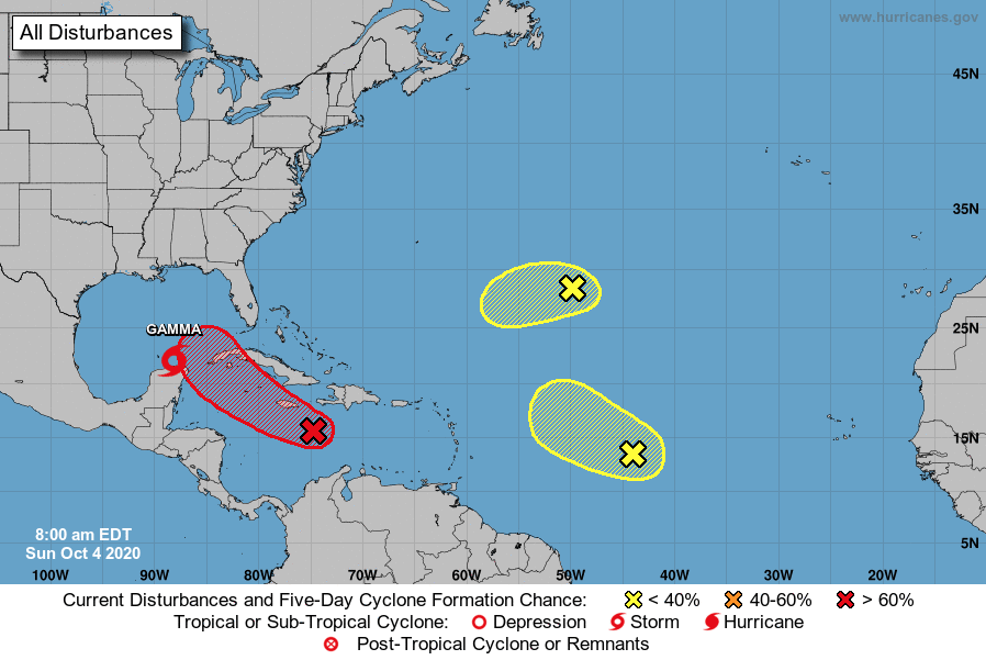
While Tropical Storm Gamma is headed away from the United States, that tropical wave in the Caribbean is something we will be monitoring into this week.
A tropical wave, accompanied by a low pressure system, is located over the central Caribbean Sea a couple of hundred miles southeast of Jamaica. The associated shower and thunderstorm activity is beginning to show some signs of organization. Environmental conditions are expected to be conducive for additional development, and a tropical depression is likely to form within the next day or two. It has a high (70 percent) chance of formation during the next 48 hours and a high (80 percent) chance during the next five days. The system should move west-northwestward at 10 to 15 mph across the central and western Caribbean Sea today through Tuesday, and then move into the southern or southeastern Gulf of Mexico on Tuesday night and Wednesday. Locally heavy rainfall and gusty winds will be possible across portions of Hispaniola, Jamaica, Cuba, and the Cayman Islands during the next few days, and interests on those islands should monitor the progress of this disturbance.

Another tropical wave is located over the central tropical Atlantic. This system has not become any better organized, and any development during the next day or so should be slow to occur while it moves west-northwestward or northwestward at 10 to 15 mph. Significant development is not expected beyond that time due to the system moving into a region of strong upper-level winds. It has a low (10 percent) chance of formation during the next 48 hours and five days.
Also, an area of disorganized showers and thunderstorms over the central Atlantic about 1000 miles east-southeast of Bermuda is associated with a surface trough of low pressure. This system is expected to move toward the west-southwest at around 10 mph, and some slow development is possible during the next couple of days before it too encounters strong upper-level winds. It has a low (10 percent) chance of formation during the next 48 hours and five days.
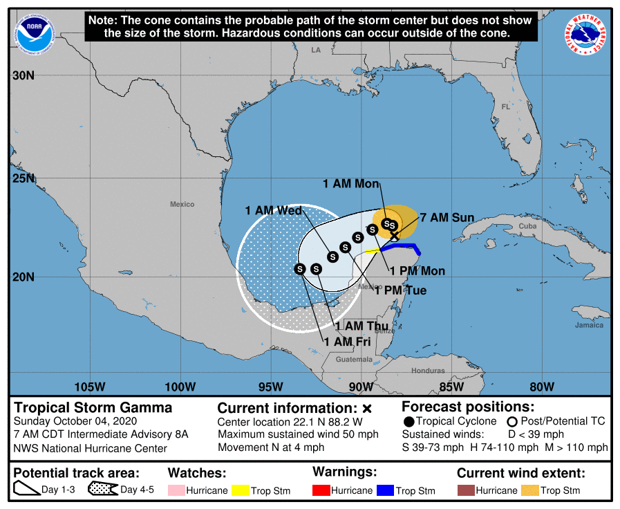 At 700 AM CDT (1200 UTC), an Air Force Reserve Hurricane Hunter aircraft has located the center of Tropical Storm Gamma near latitude 22.1 North, longitude 88.2 West. Gamma is moving toward the north near 4 mph (6 km/h), and this general motion with a further decrease in forward speed is forecast today. Gamma should turn toward the west or west-southwest tonight or Monday. On the forecast track, the center of Gamma will meander offshore of the northern Yucatan Peninsula and over the extreme southern Gulf of Mexico today, and pass near or just offshore of the northern coast of the Yucatan Peninsula on Monday and Tuesday.

Maximum sustained winds are near 50 mph (85 km/h) with higher gusts. Some re strengthening is expected today, followed by weakening tonight or Monday, which should continue into Wednesday.
Tropical-storm-force winds extend outward up to 115 miles (185 km), mainly north and east of the center. The minimum central pressure estimated from reconnaissance aircraft
data is 995 mb (29.39 inches).

