Bertha Walker
January 14, 2008James Akins
January 16, 2008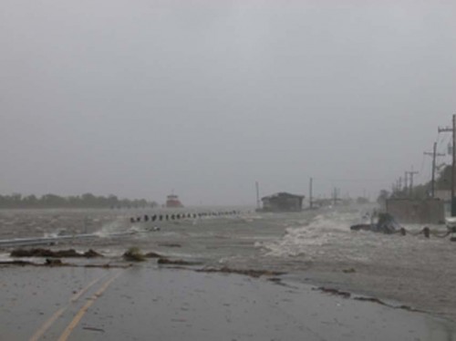
A map showing the route the new Louisiana Highway 1 will follow over marshland between Leeville and Golden Meadow should be produced by August, according to Henri Boulet, executive director of the LA 1 Coalition.
The state Department of Transportation and Development contracted with the Columbia, S.C., engineering firm Wilbur Smith Associates on Dec. 20 to produce the map, which will also indicate the location of submerged oil and gas pipelines within the right of way.

Wilbur Smith has an office in Baton Rouge.

The map will allow the state to identify the property that needs to be purchased from landowners to construct the elevated, eight-mile roadway west of the existing Louisiana 1.
“The state has never owned the marsh,” Boulet said.

The new two-lane roadway between Leeville and Golden Meadow will cost around $250 million to build, based on an estimated price of $30 million a mile. Neither the state nor the federal government has allocated any money for the actual construction of the new roadway, called Phase Two of the La. 1 project.

Hundreds of underground pipelines cross the area. Wilbur Smith will have to track down the owners before any work can start. The company will produce drawings of all the pipelines crossing the right of way.
“Some oil companies bought out one another,” Boulet said. “The company that (made) the purchase assumed control of the pipeline. Others went out of business. As from Leeville to Fourchon, we will address every pipeline crossing the new highway.”

The inactive pipelines will be removed. The active ones will need to be lowered further into the ground.

“When you deepen an active pipeline, it’s expensive,” Boulet said.
The estimated price for moving the pipelines is $4 to $5 million. The figure is based on the cost of moving the pipelines located within the right of way of the stretch between Leeville and Fourchon.
The Department of Transporta-tion and Development is paying Wilbur Smith to produce the map. The LA 1 Coalition is hoping the state will fund moving the pipelines.
“We will ask the state to fund it,” Boulet said, “but we can ask the state to fund only so much at a time.”
The coalition is asking the federal government to also pay for moving the conduits and constructing the new roadway.
Unlike the existing La. 1, the new highway will run straight. The current La. 1 follows the winding Bayou Lafourche because the land is higher along the bayou’s banks than the surrounding marsh.
Boulet said building straight roadways is cheaper than constructing curving ones.
The new La. 1 will rest on piers 22 feet above sea level. The piers will be spaced so that they are not close to pipelines.
Boulet said the pipelines will be laid at right angles to the new roadway to keep the oil-and-gas filled conduits away from the highway as much as possible.
But contractors were not able to set all the pipelines at a 90-degree angle on the Leeville to Fourchon portion, he said.
The Environmental Impact Study commissioned for Phase Two loosely identified a 1,000-foot-wide strip of marshland, which would contain the new roadway. Boulet said the state would buy enough land to accommodate a four-lane highway.
Wilbur Smith will draw a centerline on the map within that strip of land. The state would need 100 feet of property on both sides of the line.
Boulet said the LA 1 Coalition is encouraged by the progress made so far on Phase Two of the project.
Hurricane Rita served as a reminder of how vital the southern end of Louisiana Highway 1 is to residents along the coast. The new highway will rest on piers 22 feet above sea level. * Photo courtesy of LA 1 COALITION

